Realtime-tracking and nowcasting of thunderstorms (rTNT)
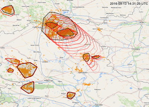
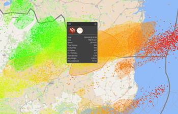
Thunderstorms normally occur in sharply delineated areas. This allows them to be easily grouped into storm cells, which are then depicted as a geographical polygon. In turn, the definition of a storm cell enables the features of the storm to be determined. The most important parameters in this respect include the size of the storm cell, number of intra-cloud and cloud-to-ground strokes, density and frequency of lightning strokes, as well as the average altitude of the intra-cloud strokes.
nowcast’s rTNT algorithm calculates storm cells in real-time. With every new lightning stroke, the cell is updated with respect to all its parameters, which are made available in real-time. Moreover, rTNT ascertains the intensity of the thunderstorm and identifies the risk of hailstorms.
If a new storm cell is tracked for a few minutes, further parameters arise such as the speed of the path taken by the storm as well as direction and development of the thunderstorm. This information forms the basis for nowcasting. The length of the nowcasting depends on the intensity and tendency of the thunderstorm.
In addition, rTNT identifies the cell nuclei which give rise to particular meteorological hazards. These areas are marked as sub-cells. With regards to the calculation of these areas, the development of the number and altitude of the intra-cloud strokes play an especially decisive role when it comes to the identification of so-called lightning jumps. In areas with particularly strong convectional currents, i.e. especially powerful upwinds, increased lightning activity is registered which, with growing storm intensity, spreads to ever-increasing altitudes. Using the information pertaining to the altitude and number of intra-cloud strokes, the intensity of the convectional currents and thus the severity of the thunderstorm may be indirectly derived.
nowcast’s cell tracking and nowcasting are based exclusively on lightning data. No additional parameters are included in the calculation.
Why cell tracking and nowcasting?
The forecasting of weather events imposes enormous demands on meteorology. Using elaborate calculation models, weather activities around the globe are recorded and anticipated. Large-scale weather patterns for specific regions may be forecasted for longer periods of time as well. Nonetheless, the exact position of a local storm cannot be forecasted even with such sophisticated models.
Lightning strokes occur in the meteorologically active area of a storm. Such areas are often also characterized by hail, heavy rain and strong gusts. As such, these zones are particularly dangerous and important in terms of damage potential, and cannot be precisely recorded using other measurement methods such as radar and satellite. In order to mark as well as project these zones and their pertinent development as nowcasting, nowcast has developed cell tracking.
Speed is the key
Unlike model-based forecasts, cell tracking and nowcasting are calculated with the aid of real-time data. In this manner, the most current weather data gathered at the moment of occurrence are included in the calculation and allow for extremely precise forecasts in chronological and geographical terms.
With cell tracking, the path taken by a storm cell can be systematically tracked and continuously analysed. The resulting nowcasting then generates precise warnings in real-time for alarm regions defined in advance.
In addition to the chronological and geographical values, the algorithm calculates the severity of a storm and if applicable issues severe weather warnings for hail, heavy rain and gales for particular areas within the thunder cell. Depending on the sensitivity of the alarm region, warnings customized to client requirements may also be issued.
How real-time tracking & nowcasting works
What may seem trivial at first – the detection and tracking of storm cells – can, in detail, only be solved with the aid of a sophisticated algorithm. This is due to the fact that storm cells are not defined by material expansion such as a cloud, but by individual lightning strokes which occur within a specific period in a specific area. In the course of time, these cells may also divide or merge. By skillfully combining the several lightning parameters measured by LINET, nowcast has developed an algorithm which allows for the meteorologically meaningful depiction of lightning cells, and provides a reliable basis for the nowcasting of thunderstorms. Since LINET is an exceptionally sensitive and fast system with an extremely high degree of measuring efficiency, a thunder cell may be reliably calculated even with low storm activity.
Lightning strokes largely occur in a sharply delineated area. This allows them to be easily grouped into storm cells, which are then depicted as a geographical polygon. In turn, the definition of a storm cell enables the features of the storm to be determined. The most important parameters in this respect include the size of the storm cell, number of intra-cloud and cloud-to-ground strokes, density and frequency of lightning strokes, as well as the average altitude of the intra-cloud strokes.
nowcast’s rTNT algorithm calculates storm cells in real-time. With every new lightning stroke, the cell is updated with respect to all its parameters, which are made available in real-time. Moreover, rTNT ascertains the intensity of the thunderstorm and identifies the risk of hailstorms.
If a new storm cell is tracked for a few minutes, further parameters arise such as the speed of the path taken by the storm as well as direction and development of the thunderstorm. This information forms the basis for nowcasting. The length of the nowcasting depends on the intensity and tendency of the thunderstorm.
In addition, rTNT identifies the cell nuclei which give rise to particular meteorological hazards. These areas are marked as sub-cells. With regards to the calculation of these areas, the development of the number and altitude of the intra-cloud strokes play an especially decisive role when it comes to the identification of so-called lightning jumps. In areas with particularly strong convectional currents, i.e. especially powerful upwinds, increased lightning activity is registered which, with growing storm intensity, spreads to ever-increasing altitudes. Using the information pertaining to the altitude and number of intra-cloud strokes, the intensity of the convectional currents and thus the severity of the thunderstorm may be indirectly derived.
nowcast’s cell tracking and nowcasting are based exclusively on lightning data. No additional parameters are included in the calculation.
With respect to defined alarm regions, the algorithm calculates the beginning, duration and end of the thunderstorm in the area affected, as well as a minute-by-minute countdown. As soon as a nowcasting intersects an alarm region, the system sends a warning to the user by email, text message, via an acoustic or optical signal.
The storm cells as well as the nowcasting are visualized in the web application LINET view, and provided to the user via LINET data in numerical form in real-time.


